Note: The information below is an excerpt from the open-access paper “Tsunami Runup and Inundation in Tonga from the January 2022 Eruption of Hunga Volcano” published in Pure and Applied Geophysics.
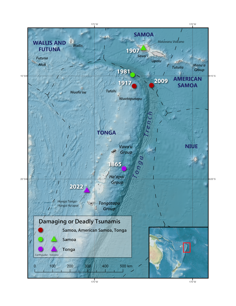
NOAA’s historical tsunami database lists 32 tsunami events affecting Tonga. Of these, 27 have a validity ranking of ‘3’ or ‘4’ (likely or definite tsunami), four have a validity of ‘2’ (questionable tsunami) and one with a ranking of ‘1’ (doubtful tsunami). In terms of the tsunami source, 27 are associated with an earthquake, four with a volcanic source and one with a source listed as ‘unknown’. Of the four events attributed to volcanic activity, two are associated with the most recent activity on the Hunga volcano (January 13 and 15, 2022) with the others referring to events in August 1892 (Validity 3) and July 1907 (Validity 2), neither of which was significant in terms of tsunami effects.
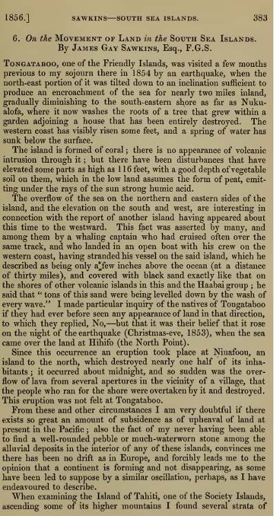
The historical accounts describe significant tsunami and tectonic effects. For example, according to contemporary anecdotal accounts (Sawkins, 1856), on Christmas Eve 1853 a severe earthquake was felt on Tongatapu. The event reportedly led to widespread subsidence of the north-eastern portion of the island leading to ~3 km of inundation, while the western side of the island was uplifted by ~1 m. Interestingly, this record also describes an “island having appeared about this time to the westward”. This island was described by the captain of a whaling ship that had run aground on it “as being only a few inches above the ocean (at a distance of thirty miles) and covered with black sand exactly like that on the shores of other volcanic islands in this and the Haabai [Ha’apai, sic] group”. The wording of this anecdote suggests that the new island was located 30 miles offshore of Tongatapu, consistent with Hunga, lying ~35 nautical miles away. We also note that Soloviev and Go (1975) transcribe the words from Sawkins (1856) as “the island was elevated about a decimetre (several inches) above the sea for a distance of 130 km (70 miles)” which, besides the erroneous numbers, seems to suggest that the low lying island was 130 km long. We believe this translation implies a completely different meaning than that intended by the captain who is paraphrased in Sawkins (1865). Also noteworthy is that the Sawkins (1865) account describes inundation of the Hihifo Peninsula area in western Tongatapu in conjunction with the aforementioned earthquake. He writes “I made particular inquiry of the natives of Tongataboo [Tongatapu, sic] if they had ever before seen any appearance of land in that direction, to which they replied. No,—but that it was their belief that it rose on the night of the earthquake (Christmas-eve, 1853), when the sea came over the land at Hihifo (the North Point)”. This last point is important in that it is the locals assuming that the formation of the new island was associated with the 1853 earthquake – an event to which they would have no direct evidence. Thus, it is possible that the two events are entirely unrelated. Particularly given that Hunga volcano is known to periodically emerge and submerge as a result of volcanic activity and also generates many felt earthquakes on Tongatapu (e.g., 2014-15, 2021-22). It is also important that this earthquake occurred on Christmas Eve, a date that would likely be remembered by the local population who had largely converted to Christianity by the 1820’s. Even considering that this is also cyclone season, it is unlikely that the “encroachment of the sea for nearly two miles inland” on the north-eastern coast of Tongatapu was caused by a tropical storm as such an event would have been well remembered by the Tongans. Hence, the validity ranking of ‘1’ for this tsunami is probably too low in the light of what we now know from the 2022 event.
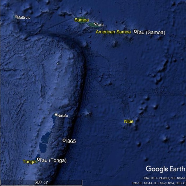
The earthquake of 1865, while strongly felt in the northern part of Tonga from Vava’u to Ha’apai only created a small local tsunami, although Okal et al. (2004) associated this event with tsunami accounts from Rarotonga and Nuku Hiva in the Marquesas Islands. As with the 1853 event discussed above, Okal et al (2004) describe how confusion over the historical record may have resulted in misinterpretation of the earthquake and tsunami effects. In this case it was the location of ‘Tau,’ an island where the ship John Wesley ran aground. At first, this was assumed by early accounts (Rudolf (1887) as cited in Okal et al., 2004) to be the easternmost island in the Samoa group; however, Okal et al. (2004) argue that it was more likely ‘Tau’, a small islet located 22 km northeast of Nuku’alofa. The more southerly location for a ship to have been grounded on a reef makes more sense when considering the earthquake location, as such an event would not have been strongly felt in Samoa. Furthermore, numerical modelling of the tsunami suggests that wave energy would have been projected to the SE and NW with much less projected northward towards Samoa.
An account from 1889 describes extreme waves from an unknown source that affected the eastern coast of Lifuka and Foa Islands in the Ha’apai group during the ‘gales of 7th and 8th March’. Reports describe a coastal forest that had been swept clean of trees and shrubs to a height of 8 m ‘along the coast for miles’, multi-ton boulders moved to elevations of 4-6 m above sea level, and areas of land being washed away with new beaches elsewhere. The reported heights were supposedly confirmed through ‘scientific measurement by three gentlemen’ who ‘demonstrate[d] that [the waves] reached the extraordinary height of 36ft [11 m] above ordinary high-water mark’. It is notable that the large waves occurred around the same time as a strong storm (likely a tropical cyclone given the time of year), however this is discounted as a possible wave source with the statement ‘the waves could not have been caused by the gale simply, which was merely a heavy blow from the S.E., but must have been created by earthquake or other upheaval some distance from the group’. The historical data also note that on March 16th the same storm wrecked several warships at anchor in Apia, Samoa and caused damage on shore in Savai’i ‘to 15 ft. above high-water mark only’, significantly less than the 36 ft measured in Tonga. Nevertheless, this event remains unexplained as there is no confirmed earthquake or volcanic event either in the near- or far-field that could be responsible for the wave.
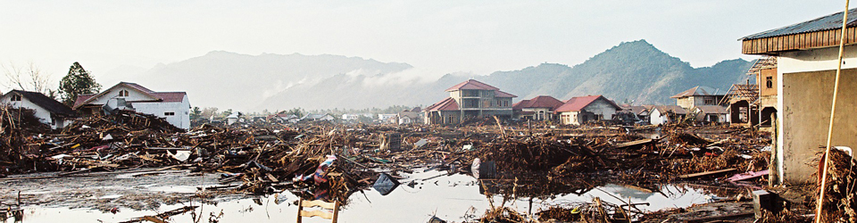
Maximum tsunami amplitudes from the historical events in Tonga have rarely exceeded 2 m (Okal et al., 2004, 2011), apart from ~10 m tsunami heights from the mysterious 1889 event, ~20 m on Niuatoputapu from the well-documented September 2009 event (Okal et al., 2010, Fritz et al., 2011) and the extreme effects from the most recent Hunga source. In the modern instrumental era, the Nuku’alofa tide gauge has recorded a tsunami amplitude greater than 0.5 m only once, in 2011 following the Great Tohoku earthquake. It is interesting that neither the 1868 Arica nor the 1960 Valdivia tsunamis, which were widely recorded throughout the Pacific, are mentioned, but effects from much smaller events, such as the 1877 Iquique earthquake are. Numerical modelling suggests that tsunami amplitudes of +/- 1.5 m and +/- 1.0 m would be expected at Nuku’alofa for the 1868 and 1960 tsunamis (Borrero, unpublished). Beyond the historical accounts, investigations into prehistoric tsunami events in Tonga include the discussion around the presence of numerous large and anomalous boulders located on Tonga’s western coast, presumed by some to have been deposited by an extreme tsunami (Frolich et al, 2009). Additionally, Lavigne et al., (2021) provide physical and cultural evidence suggesting the occurrence of a large tsunami event affecting Tonga in the 15th century. However, no causative mechanism for either of these events has been unequivocally identified.
References
- Fritz, H.M., Borrero, J.C., Synolakis, C.E. et al. (2011). Insights on the 2009 South Pacific Tsunami in Samoa and Tonga from Field Surveys and Numerical Simulations. Earth Science. Reviews, 107, 66–75. https://doi.org/10.1016/j.earscirev.2011.03.004
- Frohlich, C., Hornbach, M. J., Taylor, F. W. et al. (2009). Huge Erratic Boulders in Tonga Deposited by a Prehistoric Tsunami. Geology, 37(2), 131–134. https://doi.org/10.1130/G25277A.1
- Lavigne, F., Morin, J., Wassmer, P. et al. (2021). Bridging Legends and Science: Field Evidence of a Large Tsunami that Affected the Kingdom of Tonga in the 15th Century. Frontiers in Earth Science, 9:748755. https://doi.org/10.3389/feart.2021.748755
- Okal, E.A., Borrero, J.C. & Synolakis, C.E. (2004). The earthquake and tsunami of 17 November 1865: Evidence for far field tsunami hazard from Tonga. Geology and Geophysics International, 157(1), 164-174. https://doi.org/10.1111/j.1365-246X.2004.02177.x
- Okal, E.A., Fritz, H.M., Synolakis, C.E. et al. (2010) Field Survey of the Samoa Tsunami of 29 September 2009, Seismological Research Letters, 81(4),
- Okal, E.A., Borrero, J.C. & Chagué-Goff, C. (2011) Tsunamigenic predecessors to the 2009 Samoa earthquake. Earth Science Reviews, 107(1-2), 128–140. https://doi.org/10.1016/j.earscirev.2010.12.007
- Rudolph,E. (1887). Über submarine Erdbeben und Eruptionen. Gerlands Beiträge zur Geophysik, 1, 133–365.
- Soloviev, S. L., and Ch. N. Go (1974). A catalogue of tsunamis on the western shore of the Pacific Ocean (173-1968). Nauka Publishing House, Moscow, USSR, 310 pp. Can. Transi. Fish. Aquat. Sci. 5077, 1984.